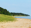

It’s easier to Live White Lake when you can find your way! Peruse the below maps of our city centers, snowmobile trails, and bike trails. Maps can be freely viewed and downloaded as .PDFs, by clicking on the thumbnail image to the left of each description.
Have questions about where to go or what to do? Our Visitors Center team members are always here to help at (231) 893-4585.
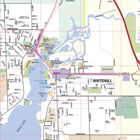
Montague and Whitehall Area Map
Our map of the White Lake Area includes the sister cities of Montague and Whitehall, as well as surrounding areas that extend east to the nearest highway - US-31. Use this map to locate primary and secondary roads, bicycle trails and state parks, shopping areas, and other important landmarks and points of interest.

West Michigan Pike Guide
Constructed between 1911 and 1922 the purpose of the West Michigan Pike was to bring automobile tourists to West Michigan from Chicago. It extended from the Indiana State Line through Muskegon to Mackinac City.
Most of the Pike was gravel or sand, but there was an early stretch between Holland and Grand Haven that was a single lane of concrete with occasional turnoff bays to allow for oncoming vehicles. In 1925 a new Federal system changed the M-11 highway designation to US-31 and portions of the route were changed and straightened. allows you to travel with a few very minor exceptions the actual 1915 route from the Muskegon County line to the City of Ludington. The only changes are where a road connector does not exist today.
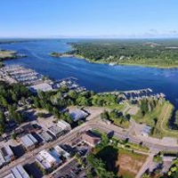
White Lake Map
Boater Safety is important when having fun on our beautiful lakes. This 2013 map of White Lake includes: water depths, boat launches and access sites, and marinas. It is not meant to be a navigational tool.
Click here or on the image to the left to view a map (PDF).
Click here for a complete handbook on boating laws.
William Field Memorial Hart-Montague Trail
Michigan’s first paved rail trail, the 22-mile William Field Memorial Hart-Montague Trail was completely rebuilt and reopened in 2016. This classic American rail trail travels by cherry and apple orchards, picture-postcard farms, woodlands and waterways. Along the way, you’ll encounter colorful clusters of wildflowers, flowing fields of asparagus, historic train depots and inviting ice cream stands. You’ll find camping and lodging at both ends of the trail and restaurants and stores in all of the small towns along the way. The name of the trail was also updated to honor the late William Field, a local asparagus and cherry farmer who was the unstoppable force behind the creation of the trail.
Fred Meijer Berry Junction Trail
Built on an abandoned C&O Railroad line, the 11.5-mile Fred Meijer Berry Junction Trail is a newly paved pathway that allows you to ride from Whitehall, south to North Muskegon. The final phase of construction was completed in June 2018 with the newest section of trail south of the McMillan Trailhead meandering through mostly oak and pine forest and crossing Bear Creek. You may continue on to Pere Marquette Beach in Muskegon through the Muskegon Lakeshore Trail or toward the Musketawa Trail toward Grand Rapids through the Laketon Trail.
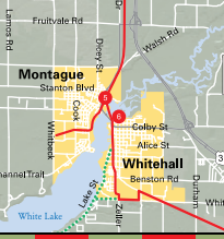
White Lake Area Snowmobile Map
West Michigan is known for excellent snowmobiling landscapes, featuring over 175 miles of well-maintained and interconnected snowmobile trails. Soar over graceful hills and valleys of the countryside and experience a thrilling Michigan winter adventure with your family and friends! The map highlights ideal places to park, eat, stay, and find gas along each route, including medical service locations and porta-potties.
The paved 22-mile Hart-Montague Trail State Park is one of Michigan's great rural rail-trails. The trail is located in Oceana County, the "asparagus capital of the world," and the town of Hart hosts the “Asparagus Festival,” complete with a parade, floats, and an Asparagus Queen, every year. Agriculture may have a hold on this area today, but Montague, Mears, and Hart all have museums [ https://www.whitelake.org/businesses/things-to-do/museums/ ] showcasing a time when the railroad and lumber industry reigned.
Your trail trip starts here
The Hart-Montague Trail State Park begins lakeside at the Montague trailhead. It then heads north for 22 miles. Or, going south, there also exists a connecting trail: The 4-mile White Lake Trailway. This shorter trail crosses White Lake River and continues through the City of Whitehall.
Whichever way you decide to go, remember that the Montague trailhead is also the spot to see the world's largest weathervane — a 48-foot structure depicting a Great Lakes schooner that went down in a 1901 storm.
Experience undisturbed scenery
The southern segment of the trail is straight and flat, with Christmas tree farms and orchards lining the path. Look for cherries, peaches, apples — and even apricots and plums!
Also be on the lookout for deer milling around in the fields and orchards, especially in the morning and evening. Springtime features a colorful and fragrant trip past the blossoming fruit trees, while autumn brings the crunch of leaves in spectacular reds, oranges, and gold hues.
Stop for a bite
As the trail moves north through the small towns of Rothbury, New Era, Shelby, and Mears, it becomes hilly and winding. Between Rothbury and Mears, there are viewing platforms with picnic tables, which offer lovely scenic views of the wooded areas.
The Village of New Era is near the halfway point of the bicycle trail. During the summer, a favorite New Era stop is Country Dairy Farm [ https://www.whitelake.org/business/country-dairy/ ] — the perfect place to grab a sandwich at the deli or a delicious ice cream cone (fresh from the farm)!
In the tows of Hart, which has plenty of places to stop for food and drinks, you’ll spot remnant prairie grasses along the trail. The gently rolling terrain offers a peaceful country ambiance with picture-perfect views.
Explore new horizons
The Hart-Montague Trail State Park winds down in the quaint town of Hart, but your adventure could just be heating up: Hart is the gateway to the beautiful beaches and giant sand dunes of Silver Lake and Lake Michigan.
Parking & Trail Access
To reach the southern trailhead in Montague, take US Highway 31 north to the Whitehall/Montague exit. Turn right on Business 31/Colby Street. Follow Business 31 past the stoplight in Montague, and find trailhead parking on the right.
To reach the Hart trailhead, follow US Highway 31 north and turn right onto Tyler Road/Main Street. Gurney Park and the trailhead are at the corner of Tyler Road and Oceana Drive.